


{{BridgeInfo.STATE_NAME}}
{{BridgeInfo.STRUCTURE_NUMBER}}
{{BridgeInfo.LTBP_BRIDGE_NUMBER}}
{{BridgeInfo.EXP_BRIDGE_NUMBER}}
Warning: This bridge has multiple NBI submittals in one year.
Attribute
Value
Historical Condition Rating Graph

 Save as Image
Save as CSV
Save as Image
Save as CSV
Historical Daily Traffic Graph
Save as Image
Save as CSV
Historical Channel and Channel Protection Condition Rating Graph
Save as Image
Save as CSV
Historical Load Rating Graph
Save as Image
Save as CSV
Historical Inventory Rating Graph
Save as Image
Save as CSV
Bridge Summary Report
{{NBISummaryReport[0][0].CATEGORY_NAME}}
{{NBISummaryReport[3][3].CATEGORY_NAME}}
{{NBISummaryReport[4][4].CATEGORY_NAME}}
{{NBISummaryReport[6][6].CATEGORY_NAME}}
{{NBISummaryReport[5][5].CATEGORY_NAME}}
{{NBISummaryReport[2][2].CATEGORY_NAME}}
{{NBISummaryReport[1][1].CATEGORY_NAME}}
{{convertedNBISummaryReport[7][0].CATEGORY_NAME}}
Bridge Summary Report
{{convertedNBISummaryReport[0][0].CATEGORY_NAME}}
{{convertedNBISummaryReport[5][5].CATEGORY_NAME}}
{{convertedNBISummaryReport[2][2].CATEGORY_NAME}}
{{convertedNBISummaryReport[6][6].CATEGORY_NAME}}
{{convertedNBISummaryReport[4][4].CATEGORY_NAME}}
{{convertedNBISummaryReport[3][3].CATEGORY_NAME}}
{{convertedNBISummaryReport[1][1].CATEGORY_NAME}}
{{convertedNBISummaryReport[7][0].CATEGORY_NAME}}
National Bridge Elements (NBE) - {{BridgeRequest.SELECTED_YEAR}}
| Element # | Element Name | Unit | Total Quantity | CS1 | CS2 | CS3 | CS4 | HI (%) |
|---|
| {{item.ELEMENT_NUMBER}} | {{item.ELEMENT_NAME}} | {{item.ELEMENT_UNIT}} | {{item.TOTAL_QUANTITY|NumberFormatter:'':0}} | {{item.CONDITION_STATE_1|NumberFormatter:'':0}} ({{item.CS_PERCENT_1}}%) | {{item.CONDITION_STATE_2|NumberFormatter:'':0}} ({{item.CS_PERCENT_2}}%) | {{item.CONDITION_STATE_3|NumberFormatter:'':0}} ({{item.CS_PERCENT_3}}%) | {{item.CONDITION_STATE_4|NumberFormatter:'':0}} ({{item.CS_PERCENT_4}}%) | {{item.HI}} |
Historical NBE Health Index (HI) Graphs
{{category[0].ELEMENT_CATEGORY}}
Save as Image
Save as CSV
Attribute |
Value |
| {{attr.text}} | {{ClimateData[attr.id]}} |
Climate Graph
Save as Image
Attribute |
{{x.MONTH | monthName}} |
|---|---|
| {{attr.text == 'Time Of Wetness, hours/year'? 'Time Of Wetness, hours/month': attr.text}} | {{x[attr.id]}} |

|
|
File Name
File Size(KB)
{{item.ZIP_FILE_NAME}}
{{item.ZIP_FILE_SIZE}}
No data is available.
View {{pagerRecords.from > 0 ? pagerRecords.to : 0 }} - {{pagerRecords.from}} of {{TotalItems}}
|
Cover Depth (inch)
Save as Image
Based on Ground Penetrating Radar (GPR) Measurements.
| << > {{ item.replace(":", " to ") }} | |
|---|---|
| Percentage of Scanned Deck Area |
Electrical Resistivity (kΩ. cm)
Save as Image
| << > {{ item.replace(":", " to ") }} | |
|---|---|
| Percentage of Scanned Deck Area |
Depth Corrected Attenuation At Top Rebar Level (dB)
Save as Image
Based on Ground Penetrating Radar (GPR) Measurements.
| << > {{ item.replace(":", " to ") }} | |
|---|---|
| Percentage of Scanned Deck Area |
Modulus of Elasticity of Concrete (ksi)
Save as Image
Based on Ultrasonic Surface Waves (USW) Measurements.
| << > {{ item.replace(":", " to ") }} | |
|---|---|
| Percentage of Scanned Deck Area |
Peak Frequency (kHz)
Save as Image
Based on Impact-echo (IE) Measurements.
| << > {{ item.replace(":", " to ") }} | |
|---|---|
| Percentage of Scanned Deck Area |
Bridge Deck Surface Crack Map
Click on the coordinates on the bridge deck surface map to display bridge images.
Bridge Deck Surface Crack Map
Save as Image
Bridge deck images are collected using RABIT Bridge Deck Assessment Tool.

• Chrome 5+
• Firefox 2+
General
| {{item.Key}} | {{item.Value}} |
| No General Data Available For This Structure | |
| No record found. |
Span Data
| Span Number | {{item.SpanNumber}} |
| Span Length (ft) | {{item.SpanLength.toFixed(2)}} |
| Straight Span? | {{item.IsStraightSpan == null ? '' : item.IsStraightSpan == 1 ? 'Yes' : 'No'}} |
| Continuous Span? | {{item.IsContinuousSpan == null ? '' : item.IsContinuousSpan == 1 ? 'Yes' : 'No'}} |
| End Span? | {{item.IsEndSpan == null ? '' : item.IsEndSpan == 1 ? 'Yes' : 'No'}} |
| Fracture Critical Span? | {{item.IsFractureCriticalSpan == null ? '' : item.IsFractureCriticalSpan == 1 ? 'Yes' : 'No'}} |
| Comments | {{item.Comment}} |
| No record found. | |
| No Span Data Available For This Structure |
Deck
| {{item.Key}} | {{item.Value}} |
| No General Data Available For This Structure | |
| No record found. |
General Girder
| Span Number | {{item.SpanNumber}} |
| Type of Shear Studs | {{item.ShearStudsType}} |
| Shear Studs Spacing (in) | {{item.ShearStudsSpacing}} |
| End Diaphragm Type | {{item.EndDiaphragmType}} |
| Intermediate Diaphragm Type | {{item.IntermediateDiaphragmType}} |
| Girder Material | {{item.GirderMaterial}} |
| Average Intermediate Diaphragm Spacing (ft) | {{item.AverageIntermediateDiaphragmSpacing.toFixed(2)}} |
| Girder Type | {{item.GirderType}} |
| Number of Girder | {{item.GirderNumber}} |
| Girder Spacing (ft) | {{item.GirderSpacing.toFixed(2)}} |
| Maximum Girder Depth (ft) | {{item.MaximumGirderDepth.toFixed(2)}} |
| Average Deck Haunch (in) | {{item.AverageGirderHaunch}} |
| Maximum Imposed Camber (in) | {{item.MaximumImposedCamber}} |
| Design Value Camber (in) | {{item.DesignValueCamber}} |
| Actual Value Camber (in) | {{item.ActualValueCamber}} |
| Variable Depth or Prismatic Girder | {{item.VariableOrPrismatic}} |
| Comments | {{item.Comments}} |
| No record found. | |
| No General Girder Data Available For This Structure |
Steel Girder
| Span Number | {{item.SpanNumber}} |
| Steel Specification | {{item.SteelSpecification}} |
| Steel Yeild Strength (ksi) | {{item.SteelYeildStrength}} |
| Steel Composition | {{item.SteelComposition}} |
| Steel Toughness | {{item.SteelToughness}} |
| Steel Girder Type | {{item.SteelGirderType}} |
| Steel Girder Unit Weight (lb/LF) | {{item.SteelGirderUnitWeight}} |
| Intermediate Vertical Stiffeners | {{item.IntermediateVerticalStiffeners == null ? '' : item.IntermediateVerticalStiffeners == 1 ? 'Yes' : 'No'}} |
| Longitudinal Stiffeners | {{item.LongitudinalStiffeners == null ? '' : item.LongitudinalStiffeners == 1 ? 'Yes' : 'No'}} |
| Coating Type | {{item.CoatingTypeCorrosionProtectionSystem }} |
| Coats of paint | {{item.NumberOfPaintCoats }} |
| Thickness of Primer (mils) | {{item.ThicknessPrimer }} |
| Thickness Second Coat | {{item.ThicknessSecondCoat }} |
| Thickness Third Coat | {{item.ThicknessThirdCoat }} |
| Year Coated | {{item.YearCoated }} |
| Color of Topcoat | {{item.ColorTopcoat }} |
| Comments | {{item.CommentsOne == null ? item.CommentsTwo : item.CommentsOne }} |
| Fatigue Details | {{item.FatigueDetails}} |
| No record found. | |
| No Steel Girder Data Available For This Structure |
Horizontal Stiffener
| Number of Horizontal Stiffeners per Beam | {{item.Number}} |
| Location | {{item.Location}} |
| Dimensions | {{item.Dimensions}} |
| No record found. | |
| No Horizontal Stiffener Data Available For This Structure |
Vertical Stiffener
| Number of Vertical Stiffeners per Beam | {{item.Number}} |
| Location | {{item.Location}} |
| Dimensions | {{item.Dimensions}} |
| No record found. | |
| No Vertical Stiffener Data Available For This Structure |
Cross Frame
| Cross Frame Type | {{item.Type}} |
| Location | {{item.Location}} |
| Dimensions | {{item.Dimensions}} |
| No record found. | |
| No Cross Frame Data Available For This Structure |
Concrete Girder
| Span Number | {{item.SpanNumber}} |
| Girder-Cement Type | {{item.GirderCementType}} |
| Design Compressive Strength at Detensioning/ Tensioning (psi) | {{item.DesignCompressiveStrengthDetensioningTensioning}} |
| Design Compressive Strength at 28 days (psi) | {{item.DesignCompressiveStrength28days}} |
| Girder Design Strength (psi) | {{item.GirderDesignStrength}} |
| Mild Steel Reinforcement - Type | {{item.MildSteelReinforcementType}} |
| Mild Steel Reinforcement - Spec | {{item.MildSteelReinforcementSpec}} |
| Mild Steel Reinforcement - Yield Strength (ksi) | {{item.MildSteelReinforcementYieldStrengthNumber}} |
| Mild Steel Stirrups - Type | {{item.MildSteelStirrupsType}} |
| Mild Steel Stirrups - Spec | {{item.MildSteelStirrupsSpec}} |
| Mild Steel Stirrups - Yield Strength (ksi) | {{item.MildSteelStirrupsYieldStrengthNumber}} |
| Prestressing Steel Reinforcement - Type | {{item.PrestressingSteelStirrupsType}} |
| Prestressing Steel Reinforcement - Spec | {{item.PrestressingSteelReinforcementSpec}} |
| Prestressing Steel Reinforcement - Yield Strength (ksi) | {{item.PrestressingSteelReinforcementYieldStrengthNumber}} |
| Prestressing Steel Reinforcement - Ultimate Strength (ksi) | {{item.PrestressingSteelReinforcementUltimateStrengthNumber}} |
| No record found. | |
| No Concrete Girder Data Available For This Structure |
Pre-Tensioned Girder
| Span Number | {{item.SpanNumber}} |
| Number of strands per girder cross section | {{item.PreNumberStrandsPerTendon}} |
| Strand Pattern | {{item.PreStrandPattern}} |
| Debonded Strands | {{item.DebondedStrands}} |
| Length of Debonding (ft) | {{item.LengthDebonding.toFixed(2)}} |
| Location of Tendons in Cross Section | {{item.LocationTendonsCrossSection}} |
| Number of Harped Strands | {{item.NumberHarpedStrands}} |
| Point Of Harp | {{item.PointOfHarp}} |
| Prestress Force After Losses (kips) | {{item.PrePrestressForceAfterLosses}} |
| No record found. | |
| No Pre-Tensioned Girder Data Available For This Structure |
Post-Tensioned Girder
| Span Number | {{item.SpanNumber}} |
| Number of Strands Per Tendon | {{item.PostNumberStrandsPerTendon}} |
| Strand Pattern | {{item.PostStrandPattern}} |
| Prestress Force After Losses | {{item.PostPrestressForceAfterLosses}} |
| Number of Stirrups, Location And Spacing | {{item.NumberStirrupsLocationAndSpacing}} |
| Duct Type | {{item.DuctType}} |
| General Girder Type | {{item.GeneralGirderType}} |
| Comments | {{item.Comments}} |
| No record found. | |
| No Post-Tensioned Girder Data Available For This Structure |
Bearing, Joints, Railing
| Span Number | {{item.SpanNumber}} |
| Bearing Type | {{item.BearingType}} |
| Expansion Joint Type and Material | {{item.ExpansionJointTypeMaterial}} |
| Barrier Type | {{item.BarrierType}} |
| Barrier Material | {{item.BarrierMaterial}} |
| Deck to Barrier Connection | {{item.DeckBarrierConnection}} |
| Comments | {{item.Comment}} |
| No record found. | |
| No Bearing, Joints, Railing Data Available For This Structure |
Approach Slab
| Abutment Number | {{item.AbutmentNumber}} |
| Span Number At Abutment | {{item.SpanNumberAtAbutment}} |
| Approach Slab Type, Materials, Dimensions | {{item.ApproachSlabMaterialsDimensions}} |
| Method of Connection of Slab to Structures | {{item.MethodConnectionSlabStructure}} |
| Approach Slab Overlay Type | {{item.ApproachSlabOverlayType}} |
| Does Width Match Bridge Width? | {{item.DoesApproachSlabWidthMatchBridgeWidthLanesShoulders == null ? '' : item.DoesApproachSlabWidthMatchBridgeWidthLanesShoulders == 1 ? 'Yes' : 'No'}} |
| Comments | {{item.Comments}} |
| No record found. | |
| No Approach Slab Data Available For This Structure |
Substructure - General
| {{item.Key}} | {{item.Value}} |
| No Substructure General Data Available For This Structure | |
| No record found. |
Substructure - Abutment Walls
| Abutment Number | {{item.AbutmentNumber}} |
| Precast Abutment? | {{item.PrecastAbutment == null ? '' : item.PrecastAbutment == 1 ? 'Yes' : 'No'}} |
| Abutment Stem Dimensions (in) | {{item.AbutmentStemDimensions}} |
| Abutment Backwall Dimensions (in) | {{item.AbutmentBackwallDimensions}} |
| Abutment Footing Dimensions (in) | {{item.AbutmentFootingDimensions}} |
| Type of Abutment Foundation | {{item.TypeAbutmentFoundation}} |
| Friction Or Bearing Pile | {{item.FrictionOrBearingPile}} |
| Type Of Pile | {{item.TypeOfPile}} |
| Pile Dimensions (in) | {{item.PileDimensions}} |
| Number of straight pile rows / Number of piles per row | {{item.NumberOfPilesOrStraightPileRows}} |
| Number of battered pile rows / Number of piles per row | {{item.NumberOfPilesOrBatteredPileRows}} |
| Comments | {{item.Comments}} |
| No record found. | |
| No Abutment Walls Data Available For This Structure |
Substructure - Pier Columns and Pier Caps
| Pier Number | {{item.PierNumber}} |
| Pier Column Shape | {{item.PierColumnShape}} |
| Pier Column Dimensions | {{item.PierColumnDimensions}} |
| Pier Footing Dimensions | {{item.PierFootingDimensions}} |
| Pier/Pile cap Dimensions | {{item.PierPilecapDimensions}} |
| Type of Pier Foundation | {{item.PierTypeAbutmentFoundation}} |
| Friction Or Bearing Pile | {{item.PierFrictionOrBearingPile}} |
| Type Of Pile | {{item.PierTypeOfPile}} |
| Pile Dimensions (in) | {{item.PierPileDimensions}} |
| Number of straight pile rows / Number of piles per row | {{item.PierNumberOfPilesOrStraightPileRows}} |
| Number of battered pile rows / Number of piles per row | {{item.PierNumberOfPilesOrBatteredPileRows}} |
| Number of Piles | {{item.PierNumberPiles}} |
| Comments | {{item.Comments}} |
| No record found. | |
| No Substructure Pier Columns and Pier Caps Data Available For This Structure |
Substructure - Wingwall
| Wingwall Number | {{item.WingwallNumber}} |
| Wingwall Dimensions | {{item.WingwallDimensions}} |
| Wingwall Footing Dimensions | {{item.WingwallFootingDimensions}} |
| Type of Wingwall Foundation | {{item.WingwallTypeAbutmentFoundation}} |
| Friction Or Bearing Pile | {{item.WingwallFrictionOrBearingPile}} |
| Type of Pile | {{item.WingwallTypePile}} |
| Pile Dimensions (in) | {{item.WingwallPileDimensions}} |
| Number of straight pile rows / Number of piles per row | {{item.WingwallNumberOfPilesOrStraightPileRows}} |
| Number of battered pile rows / Number of piles per row | {{item.WingwallNumberOfPilesOrBatteredPileRows}} |
| Comments | {{item.Comments}} |
| No record found. | |
| No Substructure Wingwall Data Available For This Structure |
Special Projects
Timber Bridges Data
Wood Detoriation Zone Map
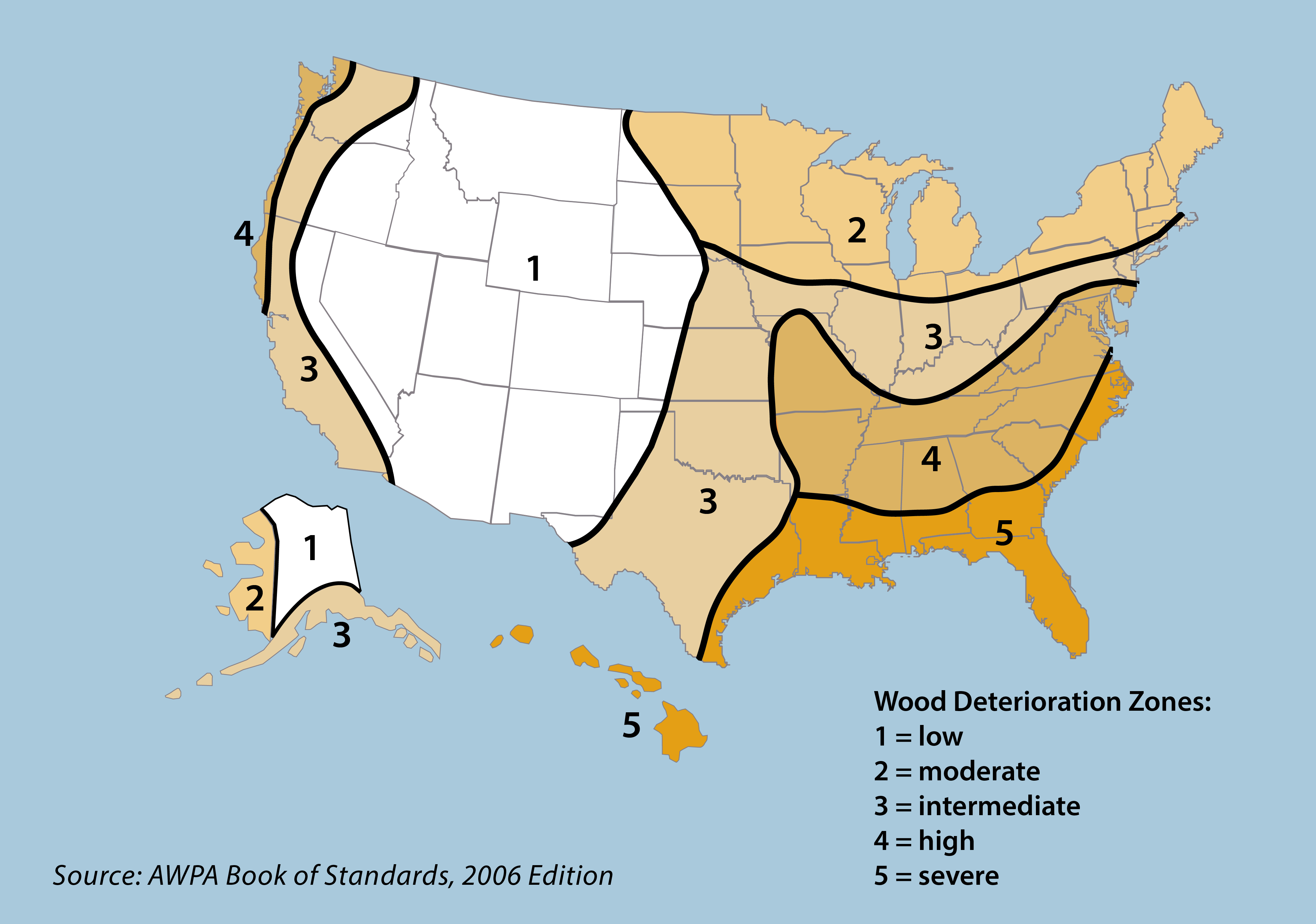
Major regional differences in potential for deterioration of wood used in contact with the ground are shown in this figure. In certain modified environments such as banks along irrigation canals or irrigated residential or agricultural lands, a higher degree of protection might be needed than would be required in the local natural environment. It must also be recognized that within individual regions, certain natural environments such as river valleys or coastlines may present greater potential for wood deterioration than the region as a whole.
Ultra High Performance Concrete (UHPC) Bridges Data
Unpainted Weathering Steel (UWS) Bridges Data
GRS-IBS Bridges Data
Internally Cured Concrete Bridge Deck Data
Warning: This bridge has multiple NBI submittals in one year.
Cover Depth (inch)
Save as Image
Based on Ground Penetrating Radar (GPR) Measurements.
| << > {{ item.replace(":", " to ") }} | |
|---|---|
| Percentage of Scanned Deck Area |
Electrical Resistivity (kΩ. cm)
Save as Image
Electrical Resistivity.
| << > {{ item.replace(":", " to ") }} | |
|---|---|
| Percentage of Scanned Deck Area |
Depth Corrected Attenuation At Top Rebar Level (dB)
Save as Image
Based on Ground Penetrating Radar (GPR) Measurements.
| << > {{ item.replace(":", " to ") }} | |
|---|---|
| Percentage of Scanned Deck Area |
Modulus of Elasticity of Concrete (ksi)
Save as Image
Based on Ultrasonic Surface Waves (USW) Measurements.
| << > {{ item.replace(":", " to ") }} | |
|---|---|
| Percentage of Scanned Deck Area |
Peak Frequency (kHz)
Save as Image
Based on Impact-echo (IE) Measurements.
| << > {{ item.replace(":", " to ") }} | |
|---|---|
| Percentage of Scanned Deck Area |
Bridge Deck Surface Crack Map
Click on the coordinates on the bridge deck surface map to display bridge images.
Bridge deck images are collected using RABIT Bridge Deck Assessment Tool.
• Chrome 5+
• Firefox 2+
The Condition Forecast models shown below are products of on-going research. They are included here for illustration purposes only.Not all bridges have models associated with them. Model documentation is available under Library/InfoBridge Documentation. Historical condition ratings are as reported under each NBI submittal. The inspection dates for these ratings may lag a few years for some bridges. For details, refer to the “Historical NBI Condition Graph” under Bridge Information/NBI


Attribute |
Value |
| Inspection Priority | {{selectedGridData.PRIORITY}} |
| MMI, Modified Mercalli Intensity | {{selectedGridData.MMI}} |
| Distance (km) (Distance of the bridge from the epicenter of the earthquake) | {{selectedGridData.DISTANCE}} |
| PGA, Peak Ground Acceleration (%g) | {{selectedGridData.PGA}} |
| PGV, Peak Ground Velocity (cm/s) | {{selectedGridData.PGV}} |
| PSA 1s, Pseudo Spectral Acceleration 1s (%g) | {{selectedGridData.PSA_1S}} |
| PSA 0.3s, Pseudo Spectral Acceleration 0.3s (%g) | {{selectedGridData.PSA_3S}} |
| Vs30, Shear Wave Velocity (m/s) | {{selectedGridData.VS30}} |